Using the University map
Controlling the map
Key & legend
For people with disabilities
Changes and errors
Paper map
Export or Print map
Sending map links and custom overlays (annotation)
Using the map on your website
Copyright and credits
Controlling the map
Note: more detailed features are shown only at higher magnifications.
Search: searching for locations responds after you type just a few characters into the search box. You'll rarely need to type the full name of the institution etc. that you are looking for. Where there is more than one similar result, click on the entry or one of the numbered location spots to get the full listing, a pin showing the location and how to get into the site and building.
Pan: to pan the map, press the left mouse button and drag (or just use one finger on a touch screen, such as an iPad). To re-centre on a search result click on the name of the institution or on the pin if you can still see it.
Zoom: to zoom in or out,
• press the '+/-' buttons (centre of zoom is on the search pin if visible or the centre of the visible area otherwise)
• click on the map to bring up the context menu and choose the '+' and '-' buttons to zoom into/out from a particular point,
• use the wheel on your mouse if you have one, or
• pinch/spread two fingers on a touch screen.
What's here: A click on the map will bring up the context menu. Choose What's here (the 'gun sights' symbol) to show you University institutions recorded within about 100m of where you clicked.
The context menu: When you click on the map, a menu of icons is shown indicating operations on that point, as follows:
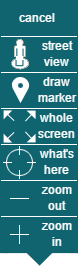 dismiss the menu (clicking anwhere else on the map also cancels)
display nearest available Google street view image to point clicked
drop marker on map at clicked point (click on marker for a menu to remove marker)
enlarge map to fill window
show institutions near to point clicked
zoom out (centred on point clicked)
zoom in (centred on point clicked)
URL: If you have panned or zoomed on the map, or placed a marker on it, you can obtain the URL of the map in that position and with any marker using 'Link to Map' on the 'More' menu. You could use a link shortening service such as
bit.ly or
t.co
Key & legend
-
University building and site boundary
 College building and boundary
 Selected non-university buildings and sites
-
University operated residential building (no public access)

-
Porters lodge / reception / security
 Building entrance for search result
 Site access point for search result (suitable for foot, cycle, motor and or service access as shown)Road
 Road with vehicle restrictions
 One-way street (many but not all one-way streets can be cycled both ways)
 Bollard (no access)
 Gate
Gate Automatic gate (restricted access)
 Service road under building / archway
 Cycleway
 Cycle parking (with number of spaces)
 Main public car parks
 Named car parks
 Railway
 Taxi rank
 Bus stations and Park & Ride
 The Busway (cycleway alongside)
 Footpath
 Path (not public)
 Steps
Steps Walkway under building / colonnade / cloister
 Wall
Wall Hedge
Hedge Church
 Lawns and green space
 Gardens, sports pitches, woods, commons and nature reserves
 River Cam, streams, lakes and ponds
 Built-up area
 Retail area and other buildings
For people with disabilities
We are hoping that the technology supporting this new map will enable more features to be displayed to support people with disabilities in the future. In the meantime, there is more information about disabled access including detailed plans of facilities on the main sites, and in the colleges.
Changes and errors
To let us know about an error or a change needed to the map, for example if a department is moving, please contact the University Information Services service desk (
servicedesk@uis.cam.ac.uk ) in the first instance.If you have a University login you can also report issues directly to the map issue tracker.
The Map uses a combination of institutional data from the University and map base data from OpenStreetMap. Errors in the public realm, such as street names etc, can be corrected directly in OpenStreetMap or notified to them at the OpenStreetMap web site by clicking the Add a note to the map button (bottom button in the top-right corner). These notes are monitored, but changes may take a while to propagate back into the University's map.
Paper map
A version of the University Map on paper can be purchased from the Press Bookshop at 1 Trinity Street.
Export/Print map
Printing directly from the browser does not give particularly good results because of limitations of layout and the lower resolution map images used to draw the map on a screen. Instead, we offer a comprehensive Export/Print facility to obtain PDF or PNG image file extracts of the map and departmental information.
This provides support for a quick "just give me what I see" to precisely sized extracts for placement in professionally printed publications.
Export print is available by clicking the Export/Print button
 (above the search box) or
Export/Print on the More menu.
(above the search box) or
Export/Print on the More menu.See the separate help page for more information.
Sending map links and custom overlays
You can obtain the URL for the current view of the map using the link button
 or 'Link to Map' on the 'More' menu, which you can send in emails or place on other web pages as required. This can include one or more coloured markers generated using the 'draw marker' option on the context menu (see above).
You can also draw points, images, text, lines and areas on top of the map (custom overlays) and send the result to other people. Choose 'Annotate the map' on the 'More' menu to do this.
Inside, this is done using a format called UCamGeoJSON. It is also possible to make such data outside the map, including dynamically produced overlays where the data being converted from another source format or is changing over time.
Using the map on your website
You can embed the map for a particular institution in your own website using an IFRAME. Only the map itself will be displayed, not the search box etc. See technical details.
You can also use the map's API to make more sophisticated use of the map images and data in your own sites.
The map also supports the oEmbed protocol. This allows map URLs pasted into compatible content management system articles to be automatically substituted for the live map represented by that URL. See more about how oEmbed works with the University map.
Copyright and credits
Map contents are copyright © OpenStreetMap contributors. The University of Cambridge has contributed significantly to the data pertaining to the University. The map contents are licensed under the Open Database license version 1.0, which means the database of base map data can be used freely with appropriate attribution. See OpenStreetMap for details of how the license relates to OpenStreetMap specifically. Under the terms of ODbL, the map database supporting the University map is available on request, though there is nothing in it that you cannot acquire through the OpenStreetMap API directly.
Map presentation (the map images) and the institution index are copyright © 2011 - 2024 University of Cambridge. See the terms and conditions under which they may be used. Colleges are surveyed by kind permission of their respective authorities.
The software for producing the map styling and the search index is licensed under the GNU General Public License. Please contact us for further information.
Map tiles are displayed using leaflet.js (license) and markdown is interpreted by showdown (license)
The map was commissioned and is maintained by University Information Services through a grant from the Information Strategy Working Group and prepared on their behalf by David Earl.


© 2013 University of Cambridge